
Mapping Narratives: How Enterprise GIS Adds Experience To Campus Maps
Telling stories through dynamic mapping using the University's shared resource
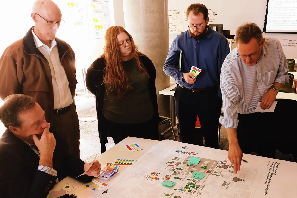
Campus planner Ed Galda (right) demonstrating priority areas on a campus map during a Campus Master Plan Workshop.
If you’ve ever used the UArizona Public Campus Map to find your way around campus, looked for available parking lots to go to a game, or found yourself curious about a certain tree you’ve seen outside of your building, then you are already acquainted with the work and resources of the UArizona Enterprise GIS (EGIS). EGIS is a service within the Department of Planning, Design & Construction (PDC) that manages the University’s spatial information and systems. The services and resources EGIS provides to end-users are used to manage assets, analyze the physical campus and institutional patterns, assist with wayfinding, and more. On the back-end, EGIS provides an enterprise-wide technical framework for integrating location-based systems and data.
GIS, or Geographic Information System, is a system that maps, manages, and analyzes various types of spatially-related data. Integrating geometric data about physical features with descriptive data about those features is at the heart of GIS. For example, on a basemap you could locate the precise position of every garbage can or wifi access point on campus and then associate attribute information with each, such as type, manufacturer, service zone, maintenance schedule, and more. GIS enables the ability to analyze and expose relationships and patterns at any scale relevant to the University, while also mapping public resources, such as pathways, classroom utilization, or trees, interactively and in real-time.
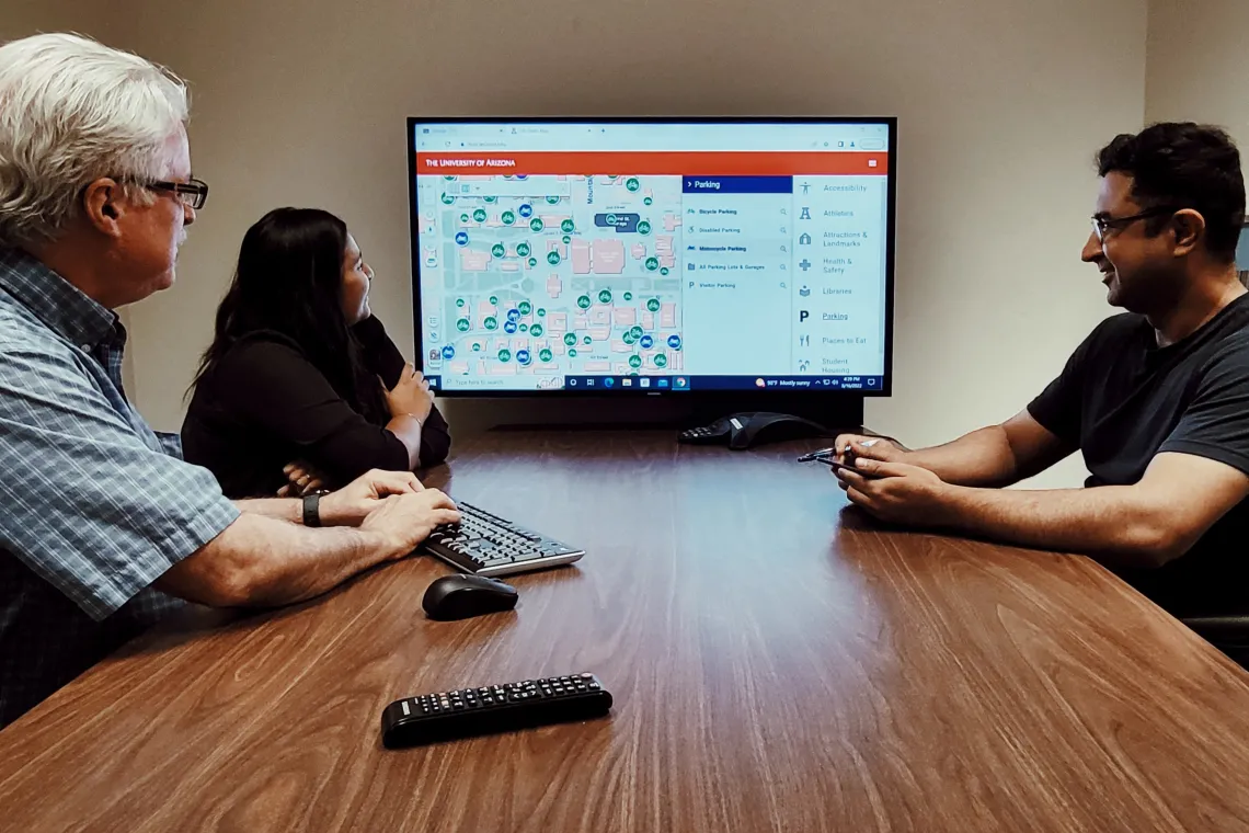
EGIS collaborated with University Parking and Transportation Services (PTS) to develop UArrive, a dynamic, interactive map application that allows users to answer campus transportation, parking, and routing questions. The web app uses GIS features curated by EGIS with guidance from PTS to inform campus users about parking and transportation options, find CatTran routes, navigate to current events, and discover locations of the closest bike parking to a particular building.
UArrive has been in continuous development for the past five years and began as a collaboration between EGIS and PTS to build interactive parking maps from older, static maps. Assistant Director for EGIS, Grant McCormick explained, “We converted PTS’s static maps into data so they could be used in interactive mapping applications.” Interactive maps require less effort to maintain than static maps, which “become out of date the day after they're made,” McCormick reflected. “With interactive, dynamic maps we could keep more live data up to date and have more flexibility in how services are delivered.”
When you view UArrive, you see public facing information, such as what you might seek out when looking for a parking spot before a game. PTS staff have an additional authenticated view to assist operations and help maintain data the public sees through UArrive. EGIS developed PTS Blueprint, a backend application that enables PTS to mark out every stall and lot type, update parking information in real-time, and reference the full set of parking features to enhance situational awareness in the field.
For the Commencement 2022 ceremonies, EGIS developed a field app to give the PTS team a way to monitor lots during the events in real-time, extending the functionality of UArrive. “The teams that were monitoring the lots could dictate if a lot was full or not for the event,” said Maree Archuleta a GIS Analyst with EGIS. “A lot would automatically be removed from the event map so that if you were going to campus and trying to figure out where to park for that event, the full lot would no longer be visible. We really put PTS in charge of managing the data, since they're the ones who understand it best and we facilitate the system for them.”
The EGIS Team. (L to R) Grant McCormick, Maree Archuleta, and Naveed Ahmed.
The power of using GIS is that it is always evolving and growing while still delivering on its foundations. Static maps can still be made from EGIS’s data by campus units to tell a story or bring visibility to what they do. As a framework for integration, it enables campus groups to input their data into the system and highlight their own thematic story, while leveraging a great depth of enterprise data to add context and richness to their narrative.
The EGIS system and enterprise geodatabase is a shared resource; a framework enabling collaboration, interaction, and integration. When there is an owner or steward of the data, like PTS, it’s their expertise that drives things. GIS creates the framework allowing their data to integrate with spatial data about assets and topics managed by other departments. Even though management of a physical resource, such as a building, may be distributed among several departments, the physical resource exists once in a physical space. Many departments can gain substantial value from having single-source-of-truth data available to leverage rather than duplicating efforts for this one building.
IT and Spatial Services staff on their way to collect drone imagery. In back is Randy Mathews, driving is Bret Linden, and on the front passenger side is Drennen Brown.
EGIS is interested in expanding their resources available to colleges and departments across the University, as it is an enterprise-wide system with data relevant to many different stakeholders, users, systems and applications. The technology behind it is mature and robust enough to accommodate warehousing much more spatial data to even better serve the campus community.
“When someone has a spatial problem to solve, or a need for mapping, we want them to think of us,” said Drennen Brown, Director of Information Technologies and Spatial Services at PDC. “It’s a lost opportunity when a disconnected solution using something underpowered and basic like Google is spun up simply because we haven’t made that connection yet. It’s a success for everyone when you can build and extend upon what’s been developed to such a high level. That’s really the goal for us."