Discovering University Facilities Services Technologies
A discovery series on the diversity and uniqueness of technology services at UArizona
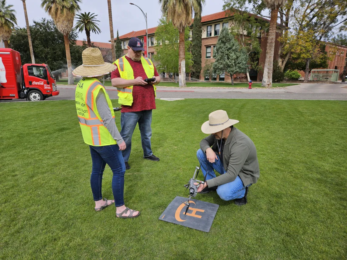
Photo courtesy of Arizona Athletics
There is a lot of innovative and essential technology at the University of Arizona that helps the institution run smoothly, safely, and at optimal levels. The University Facility Services IT ( UFS-IT ) team has specialized skills and provides services to over 600 employees, and the work they do is far reaching over multiple areas.
One of the innovative team projects they are supporting that provides untapped visibility for the university is Aerials UArizona. Aerials UArizona, which is going into its sixth year of use, comes from the curiosity of UFS-IT team. Drennen Brown, Director of UFS-IT always encourages his team to operate with a high level of curiosity when looking ahead at ways to proactively problem solve. “We support various departments, one of those being construction. There hadn’t previously been a way for the construction team to have a current, up-to-date overhead view of campus to help with their project planning. Our IT team started getting interested in drones and how we could incorporate drone footage to help solve problems.”
With the introduction of this new technology tool, came a sizeable learning curve for understanding the complexity that goes into flying a drone. “We became interested in what drones could do for us with planning, design, and construction back in 2018. There was an interesting process to go through working with University Risk Management because use of drones at the university was a new thing. “Safety is of paramount concern.”
Not just anyone can fly a drone over the University. Using a drone in this way requires a license with the Federal Aviation Administration (FAA). To secure the legal ability to fly a drone, members of Brown’s team were required to travel to an FAA facility near the airport and take a timed test on drone logistics, safety, and laws. Upon passing, the test they were issued their drone-pilot license.
“While securing the licenses, we learned what an aerial 360 image is. We wanted to determine what the largest project was that we could take on with that kind of technology now available to the University,” explains Drennen. In an aerial 360 photo, a special photo is created with 26 different angles from each point. This provides greater, broader visibility than what a normal image depicts. “To cover the main campus, we take a 360 panoramic image at 40 different points across campus, 400 feet off the ground.”
Initially the team used off-the-shelf software to join the points together into a seamless view of campus. “The results were way more than what we were expecting. As we collected multiple years of data however, we created the custom Aerials UArizona Application to compare the imagery year-to-year, add a navigation map, university branding, and enhance the user experience even more.”
“In a lot of the work we’ve done over the last 20 years, it’s about responding to problems or finding a new or innovative way to improve what’s around us. “Other times it can be more of a ‘build it and they will come’ situation, because often people won’t know what is possible until they see it. That’s definitely the case with Aerials UArizona.”
Planning, Design & Construction uses the drone footage to strategize and plan their work. The Landscaping and Grounds department was recently introduced to the technology, too. According to Brown, the potential use cases could be far greater than they know and have data on. “In all honesty, we don’t know how many people are using the tool because it is a public website. This technology is broad and designed to be used by anyone who needs to know what’s on the grounds of the campus.”
For the future of Aerials UArizona, the team sees benefits in University marketing teams taking advantage of the tool for student recruitment purposes. Drone footage has great potential to show future students the beauty of the campus before visiting Tucson.
“Something we have always encouraged is that anyone in the UFS-IT department can become a drone pilot. If anyone wants to join the Aerials UArizona Team, they can take the FAA Pilots Test and the UFS-IT team will cover the cost. UFS-IT does periodic drone work throughout the year, but for three days every spring, we cover all of campus with the help of a golf cart and capture new footage for the yearly Aerials UArizona update. It’s a lot of a fun and a great way to connect with other IT professionals and enjoy a beautiful spring day.
Aerials UArizona is only one facet the UFS-IT team supports. This team provides daily support with a variety of highly technical, essential projects related to facilities, capital construction projects, space management, real estate, business services, and enterprise GIS functions. They are regularly assessing the ways information is being stored and communicated and creating new ways to streamline processes by transitioning that information into apps for teams to be able to better use.
For more information about Aerials UArizona, please contact Drennen Brown at drennenbrown@arizona.edu